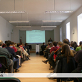

Holnap este kezdődik a Légirégészeti Kutatócsoport (AARG - Aerial Archaeology Research Group) soron következő nemzetközi konferenciája. Idén Budapesten az ELTE BTK Régészettudományi Intézet szervezésében kerül sor a rendezvényre.
További információ elérhető az alábbi címen: http://aarg2012.elte.hu
A konferencia programja:
AARG Conference 2012 - 13th – 15th September
Budapest, Hungary
Aerial archaeology, remote sensing and the archaeological process
12th sept - Day 0
19.00 22.00 Welcome Drink ( ELTE campus, building "A", groundfloor, "Kari tanácsterem" -council chamber
13th sept - Day 1
9.00 9.30 Registration
9.30 10.15 AARG AGM (Agenda pre-circulated)
10.15 10.30 Tea and Coffee break
10.30 11.00 Conference Introduction and Welcome Address
VIP(s) Speech(es)
11.00 12.40 Local session Carpathian Basin
11.00 11.20 The Application of Remote Sensing Technology and Geophysical Methods in the Topographic Survey of Early Iron Age Burial Tumuli in Transdanubia - Zoltán Czajlik, Géza Király, Attila Czövek, Sándor Puszta, Balázs Holl, and Gábor Brolly
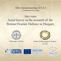
11.25 11.45 Using Remote Sensing and Non-destructive Archaeological Methods in the Research of Roman Villas and the Ancient Landscape of Pannonia - Máté Szabó
11.50 12.10 Roman Potaissa and its Surroundings. A view from above - Florin Fodorean
12.15 12.35 Archaeological and Geoarchaeological Investigations at Perkáta, Forrás-dűlő Bronze Age Fortified Settlement -László Reményi, Ákos Pető, and Árpád Kenéz
12.40 13.50 Lunch
13.50 15.30 Knowledge production
13.50 14.10 Turning Hyperspectral Pixels into Archaeological Information - Geert Verhoeven, Michael Doneus, Christian Briese, and Clement Atzberger
14.15 14.35 ALB - Airborne Laser Bathymetry: Surveying Underwater Topography - Michael Doneus, Michael Pregesbauer, Briese Christian, and Nives Doneus
14.40 15.00 Image Processing at the Service of Archaeological Survey: a Progress Report from the Silvretta Archaeological Project - Karsten Lambers and Igor Zingman
15.05 15.25 Beyond 3D Modeling in Archaeology - Metadata, Reliability and Scientific Visualization - Sorin Hermon
15.30 15.50 Tea and Coffee break
15.50 17.30 YAARG (Young AARG) session
15.50 16.20 Irish Early Medieval Settlement from the Air: A LiDAR Study of Counties Roscommon and Leitrim - Susan Curran
16.20 16.40 Google Earth and Silk Road. Satellite Reconnaissance in Xinjiang - Emilia Smagur and Kasper Hanus
16.40 16.50 First Results of Aerial Archaeology in Harghita County (Romania) - András Sófalvi
16.50 17.10 Remote Sensing Imagery in Archaeology: the Case Study of Heslington East - Jitka Jizerova
17.10 17.30 Troubles with Everything: Flying over Velebit - Vedrana Glavaš
14th sept - Day 2
9.00 10.15 Interpretation
9.00 9.20 Interpreting Remote Sensing Data in a Glaciated, Karst Lowland Landscape; What Lies in and around Rathcroghan Mound, Tulsk, County Roscommon, Ireland? - Kevin Barton and Ralf Hesse
9.25 9.45 Roads to Nowhere? Disentangling Meshworks of Holloways - Dimitrij Mlekuž
9.50 10.10 The Saint, a Mound and the Flame on the Hill: Integration of Remote Sensing Techniques on The Hill of Slane Archaeological Project - Conor Brady, Kevin Barton, and Matthew Seaver
10.15 10.30 Tea and Coffee break
10.30 12.20 Applications
10.30 10.50 To be announced
10.55 11.15 Borders: The Problems of the Aerial Archaeological Research of a Roman Limitation in Pannonia - András Bödőcs
11.20 11.50 Archaeological Three-Dimensional Recording and Reconstruction of Pharaonic and Christian Features of the Quarry Complex of Dayr Abu Hinnis (Middle Egypt) - G. J.M. van Loon, V. De Laet, A. Van der Perre, M. Hendrickx, R. Goossens, and H. Willems
11.55 – 12.15 An Experimental Application of Airborne Laser Scanning for Landscape Archaeology in Northeastern Poland - Cezary Sobczak
12.20 13.30 Lunch
13.30 14.30 Poster session
c. 20 posters on show with their authors
14.30 17.30 Discussion session: AARG, aerial archaeology and remote sensing – time for a change?
14.30 15.00 Position paper 1
A Geoarchaeologist’s View of Aerial Archaeology - David Jordan
15.00 15.30 Responses (Wlodek Raczkowski, David Stott, Simon Crutchley)
15.30 15.45 Tea and Coffee break
15.45 16.15 Position paper 2
What Next? Aerial Archaeology as Landscape Archaeology - Rachel Opitz and Steve Davis
16.15 16.45 Responses (Rog Palmer, Dave Cowley, Michael Doneus)
16.45 17.30 Questions and Discussion from the floor
19.00 Conference Dinner
Poster session (14th Sept - Day 2: 13.30 14.30)
- Andrzej Michałowski, Katarzyna Pyżewicz, Włodzimierz Rączkowski and Lidia Żuk - Searching for contexts: non-invasive support of AZP in the vicinity of Poznań
- Bartul Šiljeg - Slavonian circles
- Carmen Bem, Irina Oberlander-Târnoveanu - Looking from the air – The known and the unknown about the Romanian archaeological sites. Interpretation and preservation
- Catalin Bem, Radian Andreescu, Andrei Asandulesei, Katia Moldoveanu, Carmen Bem - The analysis and distribution of Neolithic tell settlements from Southern Romania
- Dávid Bartus, László Borhy, Zoltán Czajlik, László Rupnik and Emese Számadó - Aerial archaeological and topographical research in Brigetio
- David Stott, Doreen Boyd and Anthony Beck - From the ground up: Improving hyper-spectral prospection for archaeology
- Gabor Bertok and Csilla Gati - Highs and Lows. Expectations and first results of 140 sq kms of LiDAR survey in Baranya County, Hungary
- Gábor Bertók and Csilla Gáti - Infrared photography in aerial archaeology – case studies in Barany County, Hungary
- Helen Winton and Ed Carpenter - Green meadows surround the fence - industry on the Hoo Peninsula, Kent, England
- João Fonte, Pastor Fábrega-Álvarez, César Parcero-Oubiña and Alejandro Güimil - 3D mapping with affordable low altitude devices. A case-study on the documentation of archaeological features in the surroundings of an Iron Age hillfort in Northern Portugal
- Kevin Barton and Conor Brady with Asia Balcerzak, Kieran Campbell, Anthony Corns, Gary Devlin, Michal Pisz, Robert Shaw and Piotr Wroniecki - An International Surface Collection and Remote Sensing Field School on the Hill of Slane, County Meath, Ireland
- Lenka Starkova - The interpretation of aerial laser scanning (ALS) data through different visualization algorithms
- Lucie CULIKOVA - Remote sensing of deserted cultivated landscape
- Lukasz Banaszek - LiDARchaeology. Airborne Laser Scanning of forested landscapes of Pomerania (Poland)
- Marija Marić - Aerial survey of the Trstenik municipiality (Serbia) - a pioneering venture
- Marko Cekovic - Digital technologies in cultural landscape research, ERASMUS Intensive program
- Máté Stibrányi and Gergely Padányi-Gulyás - ARMSRACE-project. Archaeological remote sensing, field survey and predictive modelling in Sárvíz-valley, Hungary
- Matthew Oakey and Sally Evans - Chalk Lowlands and the Hull Valley NMP
- Mónika Winkler - New tumuli nearby Győrújbarát, Hungary
- Ralf Hesse - Detecting former field systems with airborne LIDAR - an overview of current methods
- Roman Brejcha - Deep in the forest by LIDAR. Post-processing of the data and ground-truthing in the forested upland in Western Bohemia.
- Sándor Berecki - Aerial Archaeological Survey of Burial Mounds in Transylvania
- Titilayo O. Olukole – A geographical information systems (GIS) database of Badagry Heritage Resources
15th sept - Day 3
AARG Field trip
Field trip to Százhalombatta (visit to the 'Matrica' Museum and the Archaeological Park as well as to the Iron Age tumulus‐site and the Bronz Age and Iron Age hillfort).
Beside the usual high‐standard lectures of the Members, the conference especially welcomes the applications of researchers of the Carpathian Basin who have not yet had the opportunity to introduce their results during previous Meetings or would like to present their research in more detail.